

This week, unusual-looking instruments can be seen moving across Lihula Castle Hill and the surroundings of the Saastna Chapel, as archaeologists use advanced geophysical survey techniques to peer beneath the ground without lifting a single spade.
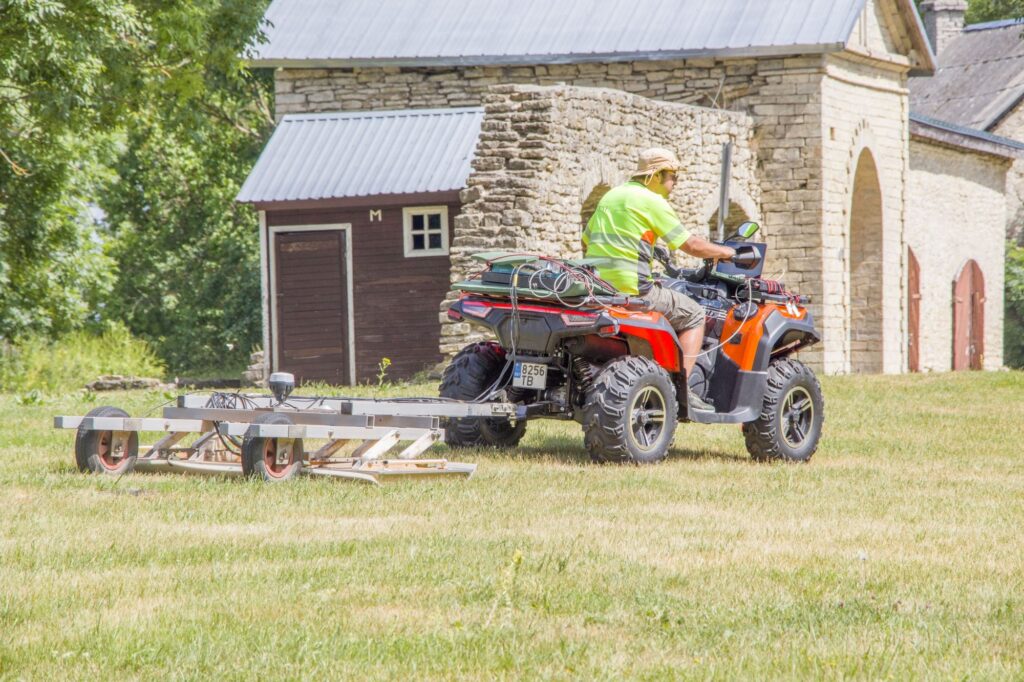
On Tuesday, Anton Pärn, Director of the Haapsalu and Läänemaa Museums, pushed a large wheeled device across the square in front of Lihula Manor. From a distance, it resembled an old-fashioned market cart. At the same time, an ATV drove around the grassy area behind the manor, towing an object that looked somewhat like an agricultural cultivator. Despite appearances, no farming was taking place. Instead, archaeologists were surveying what lies beneath the surface. The wheeled instrument was a magnetometer, while the device towed behind the ATV was a ground-penetrating radar (GPR) system.
According to archaeologist Villu Kadakas, the magnetometer detects disturbances in the Earth’s magnetic field caused by buried archaeological features and objects. The ground-penetrating radar, meanwhile, measures differences in soil density. “Areas containing more stones appear denser, while loose soil produces a weaker signal,” Kadakas explained, describing the basic operating principle of the GPR.
Together, these two technologies allow archaeologists to determine, without excavation, whether the ground conceals structures such as walls, hearths, or other archaeological features invisible from the surface but potentially of great historical significance.
“We were able to identify the remains of burnt buildings at Tarakalda in Purtse,” said historian Kersti Markus. She explained that the surveys revealed buried hearths, ovens, and the foundations of rectangular buildings. “It was truly sensational. Suddenly, the Viking Age and its houses appeared before us. It has also changed our understanding of hillforts, because until now no one had been able to demonstrate conclusively that people actually lived inside them,” Markus said. Kadakas added that Estonian hillforts are generally so large that excavating them completely to obtain an overall picture is practically impossible.
The first sites investigated this summer as part of a joint Estonian–Norwegian research project, supported by the Norwegian government, were Taramägi, located at the mouth of the Purtse River, and Tarakalda, situated three kilometres upstream. The project has now moved on to Lihula and Saastna in collaboration with a research team from the Norwegian University of Science and Technology (NTNU) in Trondheim.
According to Markus, the joint research project between Estonian and Norwegian scholars began two years ago and focuses on the journey of the Norwegian king Olav Haraldsson, who lived at the turn of the 10th and 11th centuries and was later canonised as Saint Olav, travelling between Scandinavia and Novgorod.
“The broader objective has been to identify trading centres—one on Estonia’s western coast and another on the northern coast,” Markus explained. She noted that Estonia’s western and northern coastlines formed part of the Viking maritime route linking Scandinavia with the eastern Baltic and beyond.
Purtse was selected because its location at the mouth of a river, combined with the presence of a hillfort, makes it a logical stopping point along this route. Nearby lies Olli Spring, whose name is believed to preserve a reference to Saint Olav. Likewise, the chapel at Saastna was dedicated to Saint Olav. Archaeologists investigated the chapel last summer as part of the Norwegian project, excavating its stone walls. This year, they are surveying the surrounding area with a magnetometer in the hope of locating the site’s former harbour.
Lihula was chosen because it is the only known hillfort on Estonia’s western coast that originally stood close to the sea. The other hillforts in Läänemaa are all situated farther inland.
“If we are looking for a trading centre on the western coast, Lihula is the most likely candidate,” Markus explained. “Furthermore, why was Lihula chosen as the seat of the bishopric? Episcopal centres were also centres of trade.”
While working in Lihula, the archaeologists are not limiting their investigations to the manor hill. Using both ground-penetrating radar and magnetometry, they are also surveying several other locations of archaeological interest, including the area behind the Lihula Cultural Centre, where the medieval settlement once extended, as well as the surroundings of the church and the former nunnery. Archaeologist Mati Mandel has suggested that this may have been the burial place of the Swedish warriors killed by the people of Saaremaa during the capture of Lihula Castle in 1220.
Although the fieldwork at Lihula and Saastna will conclude this week, analysis of the collected data will continue at the Norwegian University of Science and Technology in Trondheim.
“Our initial conclusions will probably be quite limited,” said Kadakas. “In some places, the first survey may reveal very little. However, we have already provided our Norwegian colleagues with a number of research questions that we hope the data will answer—and we are optimistic that the results will surprise us.”
On Thursday, 29 June, at 5:00 p.m., everyone interested is invited to Lihula Manor, where Kersti Markus, Anton Pärn, Villu Kadakas, and Carmen Cuenca-Garcia from NTNU will present the objectives of the research project and explain the high-tech methods being used to investigate Lihula’s archaeological deposits. If all goes well, the team also hopes to present the first preliminary results of the survey.
Photographs by Kaire Reiljan